Though most of Fairlington is in Arlington County, a small portion of Fairlington has been outside of Arlington since Fairlington was built. This seems odd to many people, as King Street would seem to be a natural boundary between jurisdictions, and all of Fairlington is north and east of King Street. How did part of Fairlington end up in Alexandria?
The boundary between what would become the two jurisdictions was set by a federal surveying team led by Andrew Ellicott in 1791. The team was tasked with surveying the original District of Columbia, a ten-by-ten mile square that would become the nation’s capital. The surveying team placed stones every mile on each side of the square, with one of the stones being placed in what would become Fairlington (Southwest #4). Land south and west of the boundary stones was then in Fairfax County. When the Virginia portion of the District of Columbia was returned to Virginia in 1846, land within the former District became Alexandria County, Virginia. This was renamed to Arlington County in 1920, to avoid confusion with Alexandria City, which had been independent of the county since 1870.
Leesburg Turnpike - a portion of which is now King Street - predates the Civil War. It closely aligns with the border laid out by Andrew Ellicott between Alexandria and Fairlington, until it veers slightly south of the border as it reaches what is now Interstate 395. Crucially, between 1942 and 1944 Fairlington was built north of Leesburg Turnpike, but part of it was built south of the county boundary line. That meant that part of Fairlington was in Fairfax County. Thus the name - Fair[fax]-[Ar]lington - after the two counties in which it was located. In 1952, Alexandria annexed the part of Fairfax County that included Fairlington, so the name lost its meaning.
However, the modern boundary between Arlington and Alexandria within Fairlington does not resemble the one laid out by Andrew Ellicott. It is not straight. It hews along roads that have only existed since Fairlington was built. This was the result of a 1965 land swap between Arlington and Alexandria.1 The impetus for the swap was Arlington’s need to acquire land from Alexandria to expand the county’s sewage treatment facilities. This land was well east of Fairlington, but the two counties took the opportunity to negotiate broader adjustments of their entire boundary since the state government had provided them the authority to do so.
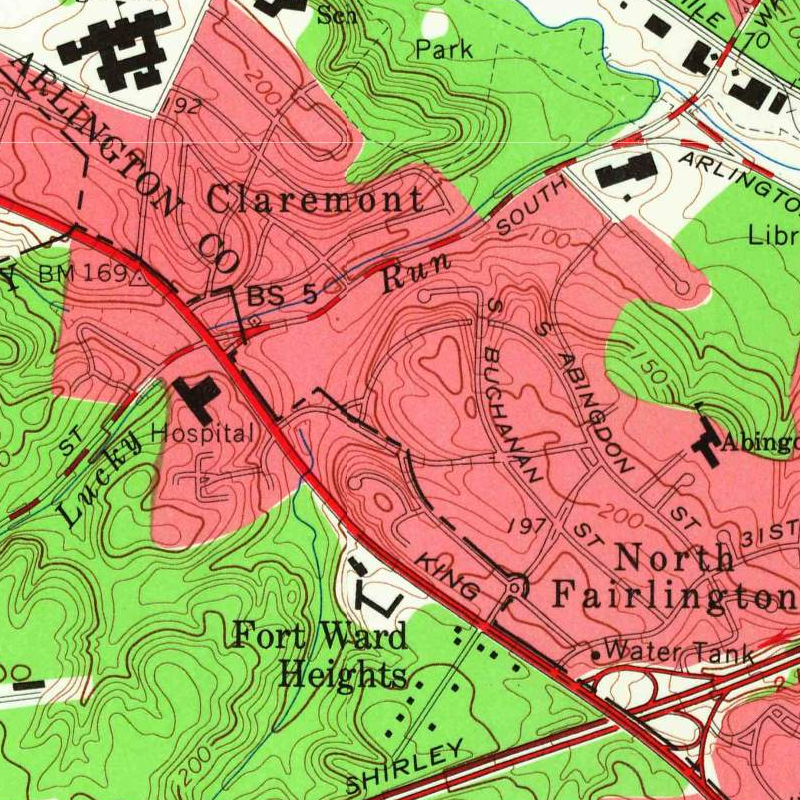
You can see the difference between the original (1956) border and the post-adjustment (1965) border from these USGS maps below.
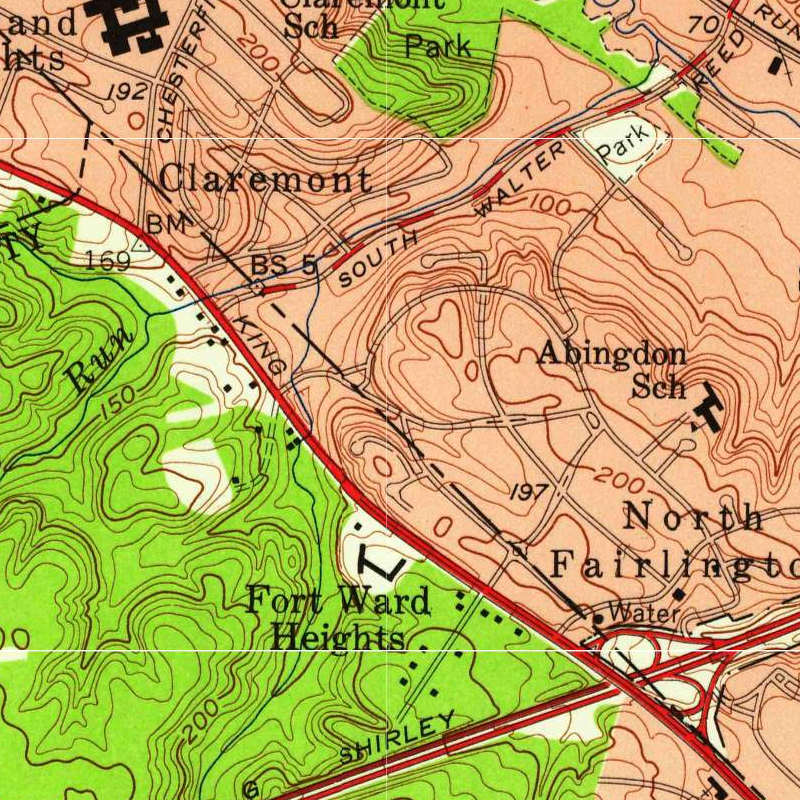
 Left: Original (1956) border. Right: Post-adjustment (1965) border. Source: U.S. Geological Survey
The original border likely created difficulties within Fairlington. In particular, South Columbus Street dipped north and south of the county border, which may have made road maintenance on that street complicated. 29th Road South and South Dinwiddie Street were in Alexandria but only reachable through Arlington, meaning Alexandria snow plows may have had to clear Arlington streets to reach their own streets. (We don’t have records of any of these challenges, but they are reasonable suppositions based on looking at the map.) The boundary adjustments made Alexandria’s section of Fairlington into a roughly rectangular shape bounded by 28th Street South, South Columbus Street, 30th Street South, and King Street. The only homes in Fairlington known to have changed jurisdictions were those in the block south of 30th Street South and South Columbus Street; within a span of thirteen years, those homes went from being in Fairfax County, to Alexandria, and then to Arlington.
Our sincere thanks to Arlington resident Bill Fogarty for researching the 1965 land swap and bringing it to the attention of the Fairlington Historical Society.
Timeline #
- 1791: Federal surveying team led by Andrew Ellicott establishes the border between the District of Columbia (Alexandria County, DC) and Virginia (Fairfax County).
- 1846: All of the District west of the Potomac was returned to Virginia. Alexandria County, DC becomes Alexandria County, VA.
- 1870: Alexandria City becomes independent of Alexandria County.
- 1920: Alexandria County is renamed Arlington County.
- 1942-1944: Fairlington is built. It is named for the two jurisdictions in which it was located (Fairfax and Arlington).
- 1952: Alexandria annexes the portion of Fairfax County that included Fairlington.
- 1965: Arlington and Alexandria agree to a land swap that established the present-day borders between the two jurisdictions.
-
A History of the Boundaries of Arlington County, Virginia. Viewable here ↩︎